


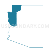
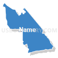
Hackberry Voting District, Mohave County, Arizona
About
Outline

Summary
| Unique Area Identifier | 525054 |
| Name | Hackberry Voting District |
| County | Mohave County |
| State | Arizona |
| Area (square miles) | 611.16 |
| Land Area (square miles) | 590.37 |
| Water Area (square miles) | 20.80 |
| % of Land Area | 96.60 |
| % of Water Area | 3.40 |
| Latitude of the Internal Point | 35.47575870 |
| Longtitude of the Internal Point | -113.80036840 |
Maps


Graphs
Select a template below for downloading or customizing gragh for Hackberry Voting District, Mohave County, Arizona


Neighbors
Neighoring Voting District (by Name) Neighboring Voting District on the Map
- Chloride Voting District, Mohave County, AZ
- Dolan Springs Voting District, Mohave County, AZ
- East Kingman Voting District, Mohave County, AZ
- Long Mountain Voting District, Mohave County, AZ
- Meadview Voting District, Mohave County, AZ
- Peach Springs Voting District, Mohave County, AZ
- Truxton Voting District, Mohave County, AZ
- White Hills Voting District, Mohave County, AZ
Top 10 Neighboring County Subdivision (by Population) Neighboring County Subdivision on the Map
Top 10 Neighboring Place (by Population) Neighboring Place on the Map
- Valle Vista CDP, AZ (1,659)
- Antares CDP, AZ (126)
- Hackberry CDP, AZ (68)
- Valentine CDP, AZ (38)
- Crozier CDP, AZ (14)
Top 10 Neighboring Elementary School District (by Population) Neighboring Elementary School District on the Map
Top 10 Neighboring Unified School District (by Population) Neighboring Unified School District on the Map
Top 10 Neighboring State Legislative District Lower Chamber (by Population) Neighboring State Legislative District Lower Chamber on the Map
Top 10 Neighboring State Legislative District Upper Chamber (by Population) Neighboring State Legislative District Upper Chamber on the Map
Top 10 Neighboring 111th Congressional District (by Population) Neighboring 111th Congressional District on the Map
Top 10 Neighboring Census Tract (by Population) Neighboring Census Tract on the Map
- Census Tract 9548, Mohave County, AZ (7,012)
- Census Tract 9507.04, Mohave County, AZ (5,995)
- Census Tract 9504.02, Mohave County, AZ (3,950)
- Census Tract 9504.01, Mohave County, AZ (2,051)
- Census Tract 9505, Mohave County, AZ (1,446)
- Census Tract 9404, Mohave County, AZ (1,288)
Top 10 Neighboring 5-Digit ZIP Code Tabulation Area (by Population) Neighboring 5-Digit ZIP Code Tabulation Area on the Map
- 86409, AZ (26,471)
- 86401, AZ (24,289)
- 86441, AZ (2,224)
- 86434, AZ (1,490)
- 86444, AZ (1,289)
- 86445, AZ (311)
- 86411, AZ (224)
- 86437, AZ (76)